







Researchers have reconstructed nearly 170 years of the history of kelp forests along Canada’s Pacific coast, finding that colder, wave-exposed waters off Vancouver Island protected most kelp forests while warmer, sheltered areas lost nearly half of them.The study mapped about 5,600 kilometres of coastline on the West Coast of Vancouver Island and found that around 88 per cent of kelp forests in cooler regions persisted over the past century. In comparison, persistence fell to 52 per cent in the warmest and most sheltered part of the coast, where higher spring and summer sea surface temperatures were linked to kelp decline.The findings come from the study, Centennial persistence of kelp forests on the West Coast of Vancouver Island, Canada, published in the journal Frontiers in Marine Science. Researchers combined British Admiralty nautical charts dating from 1858 to 1956 with Sentinel-2 satellite images collected between 2020 and 2023, creating one of the longest regional records of kelp forests in Canada.
Nearly two centuries of records brought together
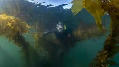
The research focused on the West Coast of Vancouver Island in British Columbia, where scientists studied two canopy-forming kelp species, bull kelp (Nereocystis luetkeana) and giant kelp (Macrocystis tenuifolia). These large brown seaweeds form underwater forests that support marine life, fisheries and coastal communities.To understand how these forests have changed over time, researchers combined historical navigation charts prepared by the British Admiralty with modern Earth observation data. The old charts marked kelp beds because they were useful landmarks for sailors, while today’s Sentinel-2 satellites can identify floating kelp canopies using their distinctive reflectance in near-infrared light.The coast was divided into four ecological regions, allowing researchers to compare how kelp forests responded under different environmental conditions across the study area.
Cold, exposed waters remained strong
The results showed a clear difference between cooler, exposed coastlines and warmer, sheltered waters.Researchers found that cooler, high-energy regions contained 97.5 per cent of today’s kelp canopy area. These same regions also recorded the highest long-term persistence, with about 88 per cent of historical kelp forests still present today.According to the study, these areas may be acting as climatic refuges, where cooler water and stronger wave action have helped kelp survive despite rising ocean temperatures and increasingly frequent marine heatwaves.The picture was very different in the warmest and most sheltered ecoregion.There, only 52 per cent of the kelp forests recorded historically were still present. The researchers linked the lower persistence to higher spring and summer sea surface temperatures, suggesting these locations are more vulnerable to climate-driven change.The authors noted that persistence does not mean kelp remained continuously present for 170 years. Instead, it refers to kelp being recorded in the same places across widely separated historical and modern observations. The available records cannot show whether forests temporarily disappeared between those surveys.
Why long-term records matter
The researchers say century-scale records are important because kelp forests naturally expand and shrink from year to year as ocean conditions change. Storms, climate cycles and marine heatwaves can all affect kelp abundance, making short-term studies less reliable for identifying lasting trends.By extending the record back to the mid-19th century, the study offers a much deeper ecological baseline than satellite observations alone. This helps scientists separate natural variation from long-term climate-driven change.The research also addresses what scientists call “shifting baseline syndrome”, where each generation comes to accept a more degraded environment as normal because earlier conditions have been forgotten. Historical records provide a clearer picture of what coastal ecosystems looked like before modern climate pressures intensified.
A mixed picture across the Pacific coast
The findings also show that kelp decline is not happening everywhere at the same rate.Large declines in bull kelp and giant kelp have already been reported in parts of California and Washington, with prolonged marine heatwaves often identified as a major cause. British Columbia has shown a more varied pattern, with some areas recording losses while others have remained stable or even increased.The new study suggests local environmental conditions play an important role in determining which kelp forests survive. Cooler, exposed coastlines appear more resilient, while warmer, sheltered waters are more likely to experience long-term losses.Researchers say these long-standing kelp refuges should be considered priority areas for conservation and restoration. Identifying places where kelp has remained stable for more than a century could help British Columbia and First Nations governments plan marine protection and climate adaptation strategies.The study, “Centennial persistence of kelp forests on the West Coast of Vancouver Island, Canada,” was published in Frontiers in Marine Science. The research reconstructed nearly 170 years of kelp distribution by combining British Admiralty charts from 1858 to 1956 with Sentinel-2 satellite imagery collected between 2020 and 2023, providing one of the most detailed long-term records of kelp forests along Canada’s Pacific coast.